Turn public parking
into a strategic asset
The first parking cadastre in France. CartograFIT makes the invisible visible, with unprecedented 98% coverage. Plan your developments, meet your regulatory obligations, and keep full sovereignty over your data.
The challenge
Cities own public space, yet they navigate blind. The State and public authorities have no centralized, exhaustive data on their parking. Without this foundational data, there is no way to plan, optimize mobility, or monetize these spaces.
FIT.ai delivers the solution
We aggregate the data
FIT.ai is a geographic data aggregator: we reorder the chaos of multiple sources and signals. Our data factory Argos aggregates, refines, scores, sorts, and structures the full spectrum of public parking — free, paid, accessible, loading, through-streets, off-street kerbs — enriched by an inventory of street furniture, road markings, and road signs, delivered as versioned datasets through CartograFIT. Unprecedented coverage of 98%.
We interpret the data
With our mapping engine and the expertise of our advisors, we help cities turn raw data into actions, revenue, and Smart City planning.
The first parking cadastre in France. Your territory. Your data. Your decisions.
Our datasets unlock real capabilities
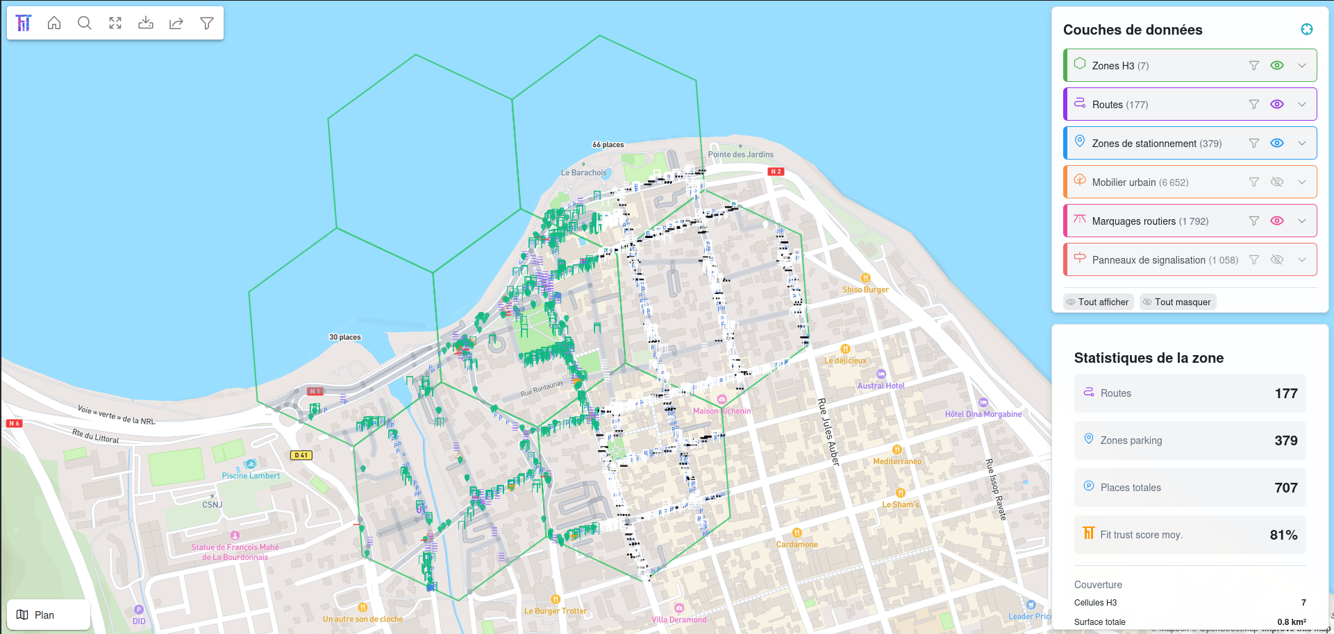
Multi-layer visualization
Parking zones, H3 cells, road network, road segments, road markings, road signs, and street furniture.
Richly qualified data
Parking type, density, confidence score, lane type — every record is qualified and scored to feed your analysis.
Full interoperability
Cross our layers with your business data in your GIS. GeoPackage with styles, GeoJSON, open formats.
Control your public assets
Legal and geographic clarity across your entire parking estate.
Generate new revenue
Through concessions, digital parking, space rental, and urban redevelopment.
Keep your sovereignty
Your territory. Your data. Your decisions.
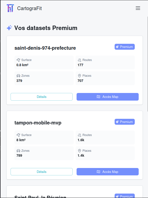
CartograFIT
Your data platform
Versioned datasets distributed via CartograFIT: 12 layers split by source (parking zones, street furniture, road markings, road signs — in terrain and HD satellite variants — plus road network, segments, and H3 cells), a built-in map preview to check your data, GeoPackage files with styles ready for your GIS.
Your territory, finally visible.
Parking density, visualized
Legal & geographic clarity
12 enriched data layers
Our Packages
One dataset subscription, options tailored to your needs
Dataset
Complete geographic data
- Full dataset (public, private, accessible, free/paid)
- 12 complementary data layers
- Formats: GeoPackage, GeoJSON (Shapefile, CSV on request)
- Map preview included
- Works with every GIS tool (QGIS, ArcGIS, MapInfo)
- Continuous updates to your data
- Open formats, no vendor lock-in
GIS Integration
Your data, inside your environment
- Ready-to-use files: styled GeoPackage, GeoJSON
- Import straight into QGIS, ArcGIS, MapInfo
- Automatic update push to your infrastructure
- API / PostGIS sync to your database or internal IT system
- Dedicated support for integration into your GIS
- Zero friction, zero dependency
Fit Audit
Bespoke data pipelines, delivered as a service
- Bespoke data pipelines, delivered as a service engagement
- Land Cover: land use per HD satellite tile
- Ready-to-use indicators: ZAN, Urban Heat Islands (UHI), APER law
- Data engineering shaped around your business challenges
- Track how your territory evolves over time
- Delivered in your formats and your tools
HD Satellite Imagery
Add-on — requires a Dataset subscription
- HD satellite imagery (0.15 to 0.30 m/pixel)
- XYZ tiles with token authentication
- A recent basemap of your territory
- Overlay our data and yours on top of the imagery
- Pre-survey: identify areas of interest before going on site
- Works with QGIS, ArcGIS, MapLibre, Leaflet
Stop driving in circles.
Three features, one obsession: never circle the block for parking again.
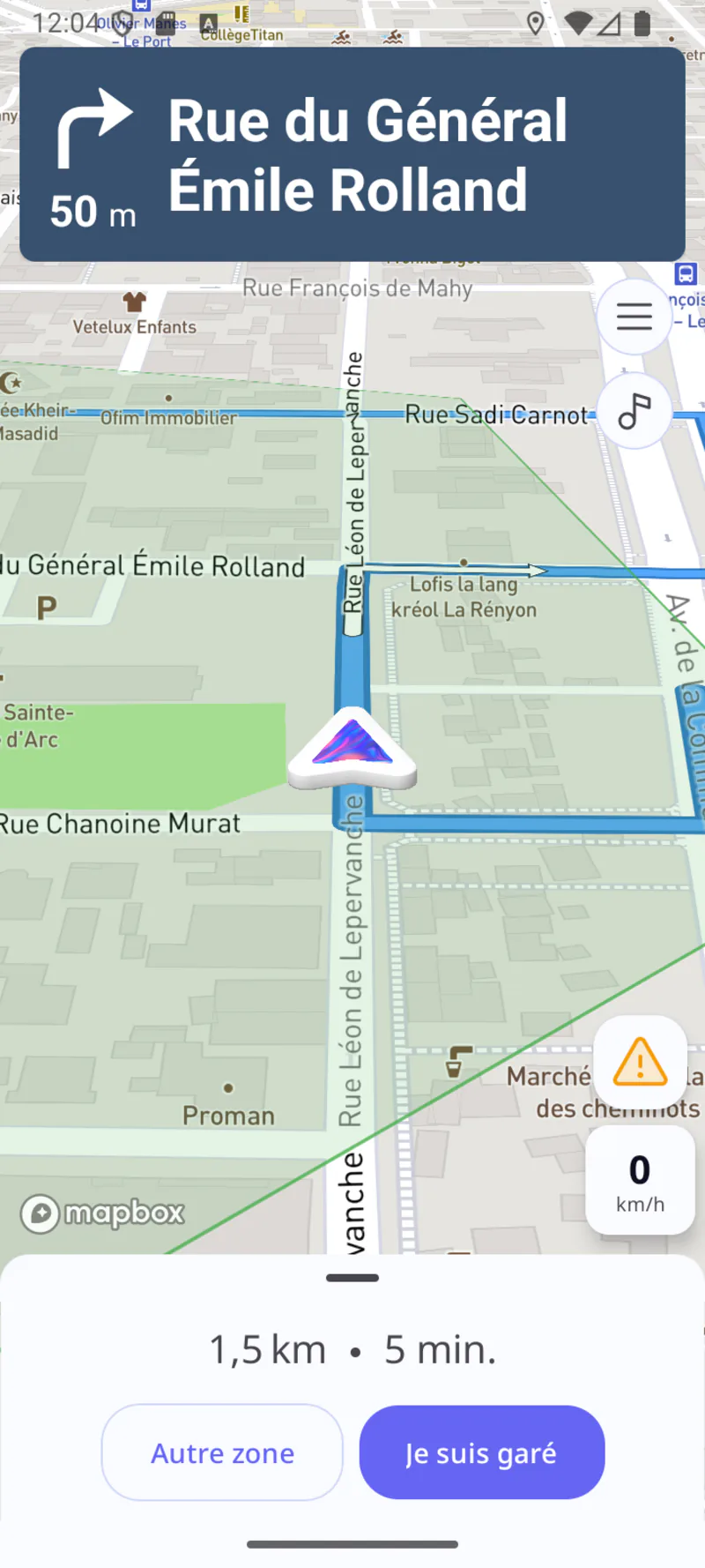
Fit Mobile
The first GPS that predicts your parking spot before you even arrive. Predictive guidance to the right zone, a fully voice-driven alert center, and automatic walking directions all the way to your destination. And on every trip, your feedback becomes eyes on the road: a feedback loop that continuously enriches CartograFIT and Argos.
The Fit Instinct
The only GPS that anticipates your spot. Our prediction algorithms take you to the zone where you are most likely to find parking.
Your voice, our compass
A fully voice-driven alert center, hands on the wheel. You speak, we turn your feedback into useful data for the community.
The last mile
From the car door to your destination. And back. Fit automatically pinpoints where you parked and guides you on foot all the way there.
FIT Innovation
FIT.ai is also a breakthrough innovation

From static inventory to predictive AI
Our foundation — the first parking cadastre in France — is a unique database that powers our predictive intelligence models.
Our R&D turns this static snapshot into a real-time stream and a continuous historical record: forecasting space availability, optimizing mobility flows, and informing planning decisions. The first phase is already validated, with a Beta app deployed in Reunion Island.
R&D built to scale on the number of inputs we integrate: the more signals we aggregate, the sharper our geographic intelligence becomes.
The Fit Mobile feedback loop adds eyes on the road: every trip continuously enriches and qualifies our data.
R&D supported by:
Technopole de La Réunion
Innovation Hub
Major Impacts
Environment
Massive CO₂ reduction
Traffic
Less congestion, smoother flows
Citizen Impact
Time saved, fuel saved, peace of mind
The FIT.ai Startup
SaaS startup based in Saint-Paul, Réunion Island (974)
The Team

Antoine Lemoine Bondallaz
CEO
University of Cambridge

Benjamin Chapoton
CTO & Head of Product
Former Lead Developer at BlaBlaCar

Matthieu Dehame
COO
Former Manager at Sweet Inn
Our supporters
Contact us
Let's turn your parking management into a strategic asset
Let's talk about your project
Our team is ready to support you in building your parking cadastre. Whether you are a city, a region or a public authority, we structure the data that fits your needs.
Location
Saint-Paul, Réunion Island